Mitsukejima in Noto Peninsular: Aerial Shot from multicopter(drone) - stock video
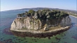
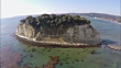
Mitsukejima in Noto Peninsular: Aerial shot from multicopter; Toward Mitsukejima turn the right side counter-clockwise to the foremost par of the island.The island is also called Gunkanjima (warship island) because of its shape.


PURCHASE A LICENSE
Get personalized pricing by telling us when, where, and how you want to use this asset.
DETAILS
Credit:
Creative #:
484108808
License type:
Rights-ready
Collection:
NHK Video Bank Creative
Max file size:
1920 x 1080 px - 1 GB
Clip length:
00:00:41:05
Upload date:
Location:
Suzu City, Ishikawa Prefecture, Japan
Restrictions:
Uses that bring NHK into disrepute, interfere with their program production or access to news gathering are not permitted.
Release info:
No release required
Mastered to:
QuickTime 10-bit ProRes 422 (HQ) HD 1920x1080 29.97i
Categories:
- 2015,
- 40 Seconds or Greater,
- Aerial View,
- Beauty In Nature,
- Clear Sky,
- Color Image,
- Day,
- Film - Moving Image,
- Geology,
- Grass,
- HD Format,
- Hashima Island,
- Horizontal,
- Ishikawa Prefecture,
- Island,
- Japan,
- Japanese Culture,
- Landscape - Scenery,
- Mitsukejima Island,
- Multicopter,
- Nature,
- No People,
- Non US Film Location,
- Outdoors,
- Pacific Ocean,
- Real Time Video,
- Rock - Object,
- Rock Face,
- Satoyama - Scenery,
- Scenics - Nature,
- Sea,
- Sites of Japan's Meiji Industrial Revolution,
- Sunny,
- Suzu - Ishikawa,
- Tranquil Scene,
- Travel Destinations,
- Tree,
- Turquoise Colored,
- Water Surface,
- Wide Shot,