Rad Through the High Sierra - stock video
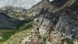
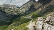
Aerial shot of the narrow, switchbacking road that leads from the town of Independence in the Owens Valley up into the High Sierra, to Onion Valley. The mountain peaks above form part of the John Muir Wilderness Area, and on the other side of Kearsarge Pass lies Sequoia and Kings Canyon National Park.


PURCHASE A LICENSE
All Royalty-Free licenses include global use rights, comprehensive protection, simple pricing with volume discounts available
€475.00
EUR
DETAILS
Credit:
Creative #:
1002232520
License type:
Collection:
Creatas Video
Max file size:
3840 x 2160 px - 3 GB
Clip length:
00:00:41:08
Upload date:
Location:
United States
Release info:
No release required
Mastered to:
QuickTime 10-bit ProRes 422 (HQ) 4K 3840x2160 23.98p
Categories:
- 4K Resolution,
- Aerial View,
- Beauty In Nature,
- California,
- Californian Sierra Nevada,
- Drone Point of View,
- Extreme Terrain,
- Film - Moving Image,
- Forest,
- Horizontal,
- Inyo County,
- John Muir Wilderness Area,
- Landscape - Scenery,
- Mountain,
- Mountain Range,
- Nature,
- No People,
- Onion Valley,
- Outdoors,
- Real Time Video,
- Remote Location,
- Rock - Object,
- Scenics - Nature,
- Sequoia And Kings Canyon National Park,
- Tranquil Scene,
- USA,
- Valley,