The Quiraing - stock photo
Also referred to as The Quiraing or Cuith-Raing is a landslip on the eastern face of Meall na Suiramach, the northernmost summit of the Trotternish or Tròndairnis (Scottish Gaelic) on the Isle of Skye, Scotland.
Taken in dramatic December weather, the stormy ephemeral light opens and beams of short lived godrays radiate down over the spiked land formation called The Cleat, Loch Cleat, and Loch Leum na Luirginn below. The highest ridge to the right is called Dun Dubh, and the interesting craggy dinosaur back - shark fin formation on the lower right is called Cnoc a Mheirlich.

Get this image in a variety of framing options at Photos.com.
PURCHASE A LICENSE
All Royalty-Free licenses include global use rights, comprehensive protection, simple pricing with volume discounts available
€300.00
EUR
Getty ImagesThe Quiraing High-Res Stock Photo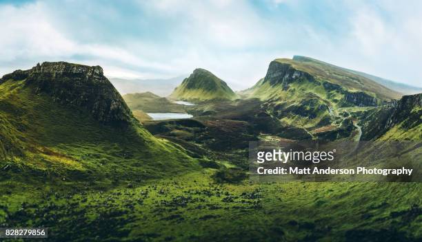 Download premium, authentic The Quiraing stock photos from Getty Images. Explore similar high-resolution stock photos in our expansive visual catalogue.Product #:828279856
Download premium, authentic The Quiraing stock photos from Getty Images. Explore similar high-resolution stock photos in our expansive visual catalogue.Product #:828279856€300€40
Getty Images
In stockDETAILS
Credit:
Creative #:
828279856
License type:
Collection:
Moment
Max file size:
9323 x 5363 px (31.08 x 17.88 in) - 300 dpi - 21 MB
Upload date:
Location:
Isle of Skye, Scotland, United Kingdom
Release info:
No release required
Categories:
- Landscape - Scenery,
- Mountain,
- Scotland,
- Scottish Highlands,
- Awe,
- Majestic,
- Isle of Skye,
- Cliff,
- Island,
- Mountain Range,
- Irish Culture,
- Lake,
- High Angle View,
- Dragon,
- Europe,
- Horizontal,
- Rebellion,
- Rock - Object,
- Emerald Green,
- No People,
- Edinburgh - Scotland,
- Glencoe - Scotland,
- Moor,
- Dramatic Landscape,
- Tranquility,
- UK,
- Climate Change,
- Mountain Ridge,
- Sunbeam,
- Heaven,
- Travel Destinations,
- Atmospheric Mood,
- Color Image,
- Concepts,
- Photography,
- Quiraing Needle,
- Beauty In Nature,
- Capital Cities,
- Dramatic Sky,
- Extreme Terrain,
- Hebrides,
- Imagination,
- Journey,
- Moody Sky,
- Outdoor Pursuit,
- Outdoors,
- Quirang,
- Recreational Pursuit,
- Social Issues,
- The Crusades,
- Three Sisters of Glen Coe,
- Tourism,
- Tranquil Scene,
- Travel,
- Vacations,